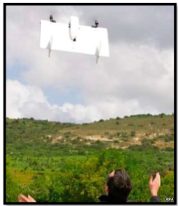
The use of radio controlled unnmanned aerial vehicles aka ‘drones’, has exploded in popularity across the globe, mainly due to the developments in technology enabling them to be mass produced at low cost for hobby craft enthusiasts, and our fascination with filming ourselves and the world around us. Even ‘cheaper-end’ models now come with basic in-built camera’s as standard, and have a 100 meter plus range that can be ‘snapped up’ for as little as £50-£100!
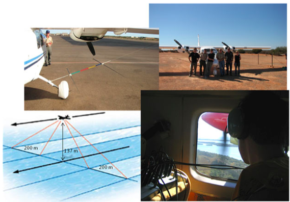
Aerial surveys have been used for many years by scientists to monitor population abundance and distribution trends. This information can be used to determine important areas of habitat for a particular species, their health and behaviour, and help inform management on how best to conserve the animals. Traditionally, this would involve the use of a standard aircraft type, flying at a set altitude and speed along a designated transect line, typically with four observers on board calling out sightings as they see them in real time, with a fifth person co-ordinating the flight and recording the sightings, in addition to the pilot.
Aerial surveys for dugongs are usually conducted by a team of five plus the pilot. The observers record all dugongs within a set area on either side of the aircraft. That area is marked by the rods attached to the outside of the plane. Monitoring population status of many marine mammal species through the use of aerial surveys is crucial for effective conservation and management. Many scientists now feel drones operating under autopilot and mounted with GPS and imaging systems have the potential to replace manned aerial surveys and provide an improved method for monitoring marine mammal populations.
Why are Drone better?
Reduced costs: Aerial surveys are labour intensive and expensive – drones can potentially significantly reduce costs.
Eliminates human risk: Drones totally eliminate the human risk factor involved in having a team of five plus the pilot flying low and slow over vast expanses of ocean.
Non-invasive: Drones offer a non-invasive means of surveying wildlife, so the animals are more likely to behave naturally and are not negatively affected.
Better data: Drones can potentially provide more accurate sightings and identification of species, more precise locations and less biased abundance estimates. They also don’t tire out!
In recent years, there have been a number of aerial surveys conducted on terrestrial and marine animals using drones including:
Helping rangers protect the critically endangered white and black rhino’s from poaching in Kenya.
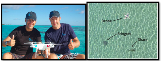
Investigating the presence of juvenile sharks and rays in shallow habitats in Moorea, French Polynesia.
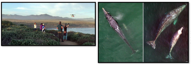 Monitoring wild populations of grey whales off the US coast.
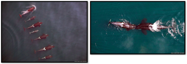 Monitoring killer whale populations off the coast of British Colombia, Canada.
Perhaps the most ground breaking use of drones is not in their visual recording capabilities (impressive as they are), but rather their usefulness as a tool to collect cetacean ‘blow’ samples. The blow of a cetacean (including all whales dolphins and porpoises) contains within it the individuals DNA make up and genetic coding; a prime indicator of health.
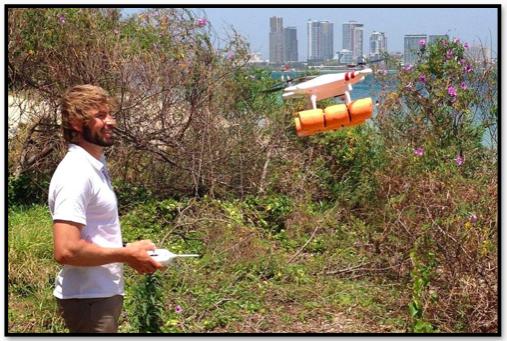
In a recent pilot study in Queensland, Australia, a team of researchers headed by Dr Meynecke (Griffith University) used a drone to hover metres over migrating humpback whales, collecting whale mucus from blow samples in a simple petri dish. Timing was critical as the whales only surfaced to breathe every 3 to 4 minutes. The study’s aim was to try and establish whether the increase in whale population is placing pressure on the species. About 19,000 humpbacks leave Antarctica’s cold waters annually and migrate up Australia’s east coast. An estimated 40,000 humpbacks once migrated to Queensland’s warm waters but commercial hunting reduced the population to fewer than 500. Whaling ended in the early 1960’s and since then the population has steadily grown to almost 20,000.
Dr Meynecke said he suspected the increased numbers coupled with temperature changes and decreasing krill stocks were affecting the humpbacks’ immune system. A total of 11 samples were collected during the pilot study, which Dr Meynecke felt was a suitable number to deem the trial a ‘success’. The mucus particles are currently being examined and if the right information is contained within them, a larger study is due to be conducted later this year, when the whales return to Queensland.
Due to the highly mobile nature of humpback whales and their often evasive behaviour (especially when calf’s are present) without the use of drones, collection of blow samples would be practically impossible, leaving much more invasive means of testing for disease like taking skin samples one of the only viable options. A similar study to this is also been carried out on fin whales (Balaenoptera physalus) in the Mediterranean Sea. EDMAKTUB is carrying out the first dedicated visual and acoustic studies on fin whales in this location through vessel-based random transect surveys, to investigate their presence within an area of shallow waters (150-300m depth) between the provinces of Tarragona and Barcelona, during the spring seasons of 2014-2019. This project aims to study and better understand the ecology of this species and determine possible migratory routes in the western Mediterranean basin, by developing a major platform for research, tracking and identification of this species in the Balearic Sea.
It aims to determine fin whales’ abundance, distribution, habitat use, behaviours and degree of residency in respect to oceanographic and physiographic variables within the study area that could make this area such a remarkable habitat for this species during their migrations across the Mediterranean. In addition to using a drone to collect each individual’s blow in order to gain genetic samples, data is obtained from visual surveys, opportunistic sightings by local commercial fishermen and opportunistic sightings by recreational users in the study area.
In order for drones to become a viable research tool, they must to some degree be able to perform autonomously (from auto-pilot) and be of a certain specification.
The ‘musts’ include having in-built:
- Compass and GPS sensors for orientation and precise navigation
- Altimeter controlling the crafts altitude
- A loiter function (enables the craft to hover continuously at the same altitude)
- A return to launch (RTL) function in case of emergency. (Autonomously returns to the craft to the same spot it took off from).
Through the use of advanced open source software like Mission Planner, it is now possible to configure virtually every single parameter to optimise the crafts performance and tailor this to the specific job it has to do, like collecting blow samples from cetaceans. There are also extra autonomous features like designating ‘way-points’ using Google earth, which instructs the drone to fly to precise locations in a set order, altitude, speed and direction, a ‘follow-me’ function enabling the craft to always follow the controller, and ‘geo-fences’ which allows exact control of how high and far the drone is allowed to fly from the controller. Having these extra functions is of great benefit, especially when you are filming and collecting data from live, sensitive subjects like marine mammals. The addition of First Person View (FPV) flying is also now possible on many drones enabling the craft to be guided through the sight of the attached camera. This massively increases the potential range the vehicles can fly and its capabilities. Some of the latest drones are now also ‘waterproof’, enabling the craft to not only land on water but also be driven through water!
It is IMPORTANT to note that although drone flying can be great fun and have many beneficial uses, there are strict FAA rules and regulations governing how and where they can be flown, and any filming or research of bottlenose dolphins (and other cetaceans) requires a special permit as they are a highly protected species in many countries including the UK.
So where does Sea Watch come in?
Sea Watch Foundation, under the direction of Dr. Peter Evans has been collecting data on cetaceans (mainly bottlenose dolphins) for over 40 years, and has built up a comprehensive catalogue of identifiable dolphins through photographic records of their dorsal fins. Much like the human finger print, a dolphin dorsal fin is unique to each individual in terms of shape and size, and many animals have bite and other permanent markings from the aggressive encounters the species are often involved in.
Many of these photographs were taken during survey trips in and around Wales, when other data such as dolphin abundance, distribution, group dynamics, behaviour and boat interactions were also recorded. Through the use of drones and visual recordings, it may be possible to further these data sets, and gain a greater understanding of the dolphins, their lifecycle and potential threats, enabling more effective conservation and management of this highly mobile, intelligent and protected species.
Although the use of drone technology for research purposes is not something Sea Watch is currently involved in, due to growing evidence from many scientists and researchers around the world using drones in innovative and ground-breaking ways in important marine mammal studies, it is something that is being investigated and could form part of the organisation’s future research plans.
Written and complied by Charles H. J. McGibney, Sea Watch Research Intern 2015.
References:
Murdoch University Cetacean Research, 2015
http://saveourseas.com/project/shark-spy-birds-eye-view/
http://www.bbc.co.uk/news/science-environment-32935898
http://www.edmaktub.com/eng/finwhaleproject/




Pingback: Sea Watch Foundation » Drone gives glimpse of large pod of bottlenose dolphins off Abersoch